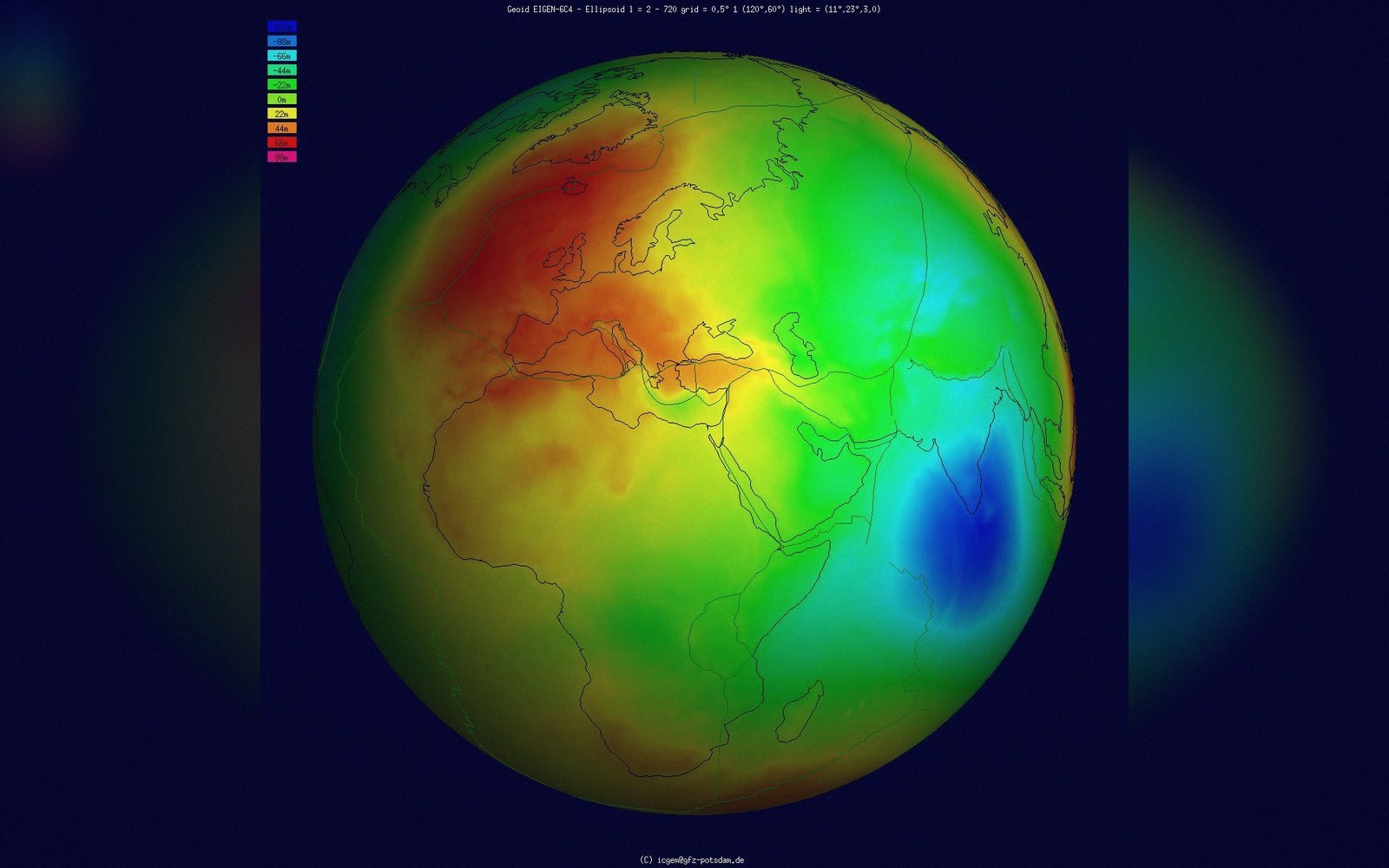
 Plate 01
Ellipsoid and geoid
Two models of Earth's shape: one is mathematically clean, the other physically real. Height depends entirely on which one you mean.
Geoid separation from the ellipsoid, exaggerated: tens of metres between the mathematical figure and where gravity actually is.
Photo: Geoid undulation to scale · Wikimedia Commons
The smooth figure and the lumpy one
A sphere is a workable first guess at Earth's shape, but even casual geodesy improves on it. Rotate a fluid body and centrifugal force flattens the poles, producing an oblate spheroid — an ellipsoid of revolution, defined by two numbers: a semi-major axis along the equator and a slightly shorter semi-minor axis through the poles. GRS 80, adopted in 1980 and the foundation of most modern coordinate systems, gives the equatorial radius as roughly 6,378,137 metres and a flattening of about 1 part in 298.257. That figure is exact enough to position a satellite to within a metre, provided you are not doing anything that depends on where water drains.
Water drains downhill, and "downhill" is not a mathematical concept — it is a gravitational one. Gravity varies across Earth's surface because mass is distributed unevenly: dense oceanic crust pulls harder than a continental plateau, mountain roots deflect it sideways, iron-rich intrusions tug it down. The surface of equal gravitational potential that, if the sea were calm and could extend through the continents, would coincide with mean sea level is called the geoid. It undulates above and below a reference ellipsoid by up to roughly 100 metres globally — a bulge over New Guinea, a depression south of India — in patterns that follow the planet's internal structure rather than its outer skin.
Why height is the difficult case
If you want horizontal position — latitude and longitude — the ellipsoid is entirely adequate. A GNSS receiver computes ellipsoidal height: the perpendicular distance above the smooth mathematical surface. This is geometrically consistent, globally defined, and continuously improving as satellite geodesy refines the reference frame.
But a civil engineer who needs to know which way a pipe drains does not want ellipsoidal height. She wants orthometric height — height above the geoid — because a fluid at rest sits on the geoid, not on the ellipsoid. The relationship between the two is the geoid undulation, often written N: orthometric height equals ellipsoidal height minus N. Except that computing N to the centimetre requires a geoid model derived from painstaking combinations of satellite gravity data, shipborne and airborne gravimetry, and surface measurements. National mapping agencies publish these models — EGM2008 and its successors cover the globe; denser national models serve where accuracy matters most — and they are periodically revised as the underlying gravity surveys improve.
 Plate 2
Every drawn grid is an agreement about where things sit — on tracing paper as much as on a screen.
Photo: Ksenia Chernaya / Pexels
The practical consequence is that two points reporting the same GNSS ellipsoidal height can still have water running from one to the other if the geoid is not level between them. Surveyors who missed that distinction have produced drainage schemes that do not drain. The map that uses GNSS heights without a geoid correction looks right until water disagrees.
What the datums actually encode
A geodetic datum is, at its core, a choice of ellipsoid together with an anchor that ties the mathematical surface to the physical Earth. Classical horizontal datums — NAD 27 in North America, OSGB 36 in Britain — were fitted to the geoid as locally known, which is why they diverge from modern geocentric ellipsoids by tens of metres in some regions. A separate vertical datum encodes a choice of reference surface for height, typically mean sea level as measured at a specific tide gauge over a specific period. That surface is the local geoid, not the global one, and it is not flat: mean sea level in New York sits at a different geopotential level than mean sea level in Amsterdam.
Modern three-dimensional datums such as ITRF and its regional realisations use a geocentric ellipsoid and publish geoid models alongside, so users can convert between geometric and physical heights explicitly. The conceptual housekeeping this demands — keeping track of which height you have, which geoid model was applied, which epoch the frame refers to — is where coordinate metadata earns its keep. The number on its own is not the position. The full specification of how that number was produced is what makes it usable.
Also in Datums & Coordinates