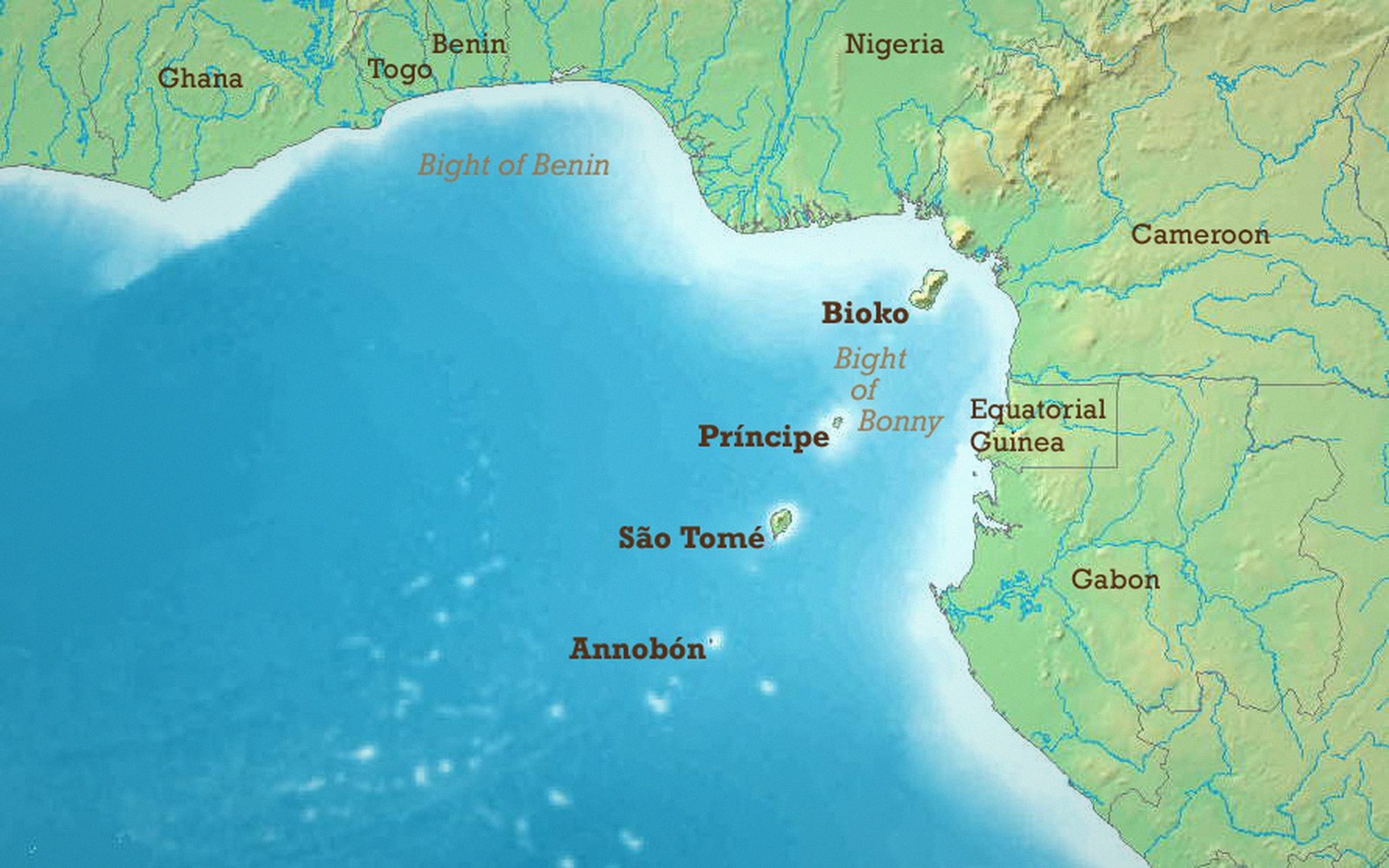
 Plate 01
The Gulf of Guinea problem
When a coordinate pair reads (0, 0), the point is probably not in the ocean west of Ghana — it is a data field that was never filled.
Where the equator crosses the prime meridian: open water, and the destination of every layer whose reference system was never set.
Photo: Gulf of Guinea (English) · Wikimedia Commons
The most common symptom no one warns you about
Load a dataset and zoom to extent. If the view snaps to a patch of open Atlantic a few hundred kilometres south of Accra, you have company. The Gulf of Guinea — centred, almost theatrically, on the intersection of the prime meridian and the equator — is where bad coordinate data goes to accumulate. The point at (0° longitude, 0° latitude) sits in international waters, well clear of any landmass, which means a cluster of dots there is almost never real. It is null, misread as zero.
The mechanism is simple. Longitude and latitude are stored as signed decimal numbers. A record with no geometry, a field that failed to parse, or an export that dropped spatial columns entirely still occupies a row. That row needs something in the coordinate fields, and the integer zero is what databases and spreadsheets supply when nothing else is given. Zero is not "unknown" in most schemas; it is a perfectly valid number that happens to resolve to a precise location in the equatorial Atlantic. The Gulf of Guinea swallows every unset position that falls through without a null check.
What it reveals about the pipeline
A cluster at the origin is diagnostic. It tells you, at a glance, that the data passed through at least one stage where coordinate validity was never tested. The source may have had no geometry at all — addresses that were never geocoded, GPS tracks that failed to record, sensor readings that timed out. Or the geometry existed but the coordinate reference system was declared incorrectly, so the reprojection engine received values it could not sensibly transform and substituted zero. Either way, the map is lying: those points did not occur in the Gulf of Guinea, and plotting them there misrepresents both the data and the blank ocean beneath them.
The fix is upstream, not cosmetic. Filtering out (0, 0) before rendering clears the symptom without touching the cause. The right response is to go back to the source record, establish whether real coordinates exist somewhere — in a geometry column, in a separate longitude/latitude pair, in an address field that could be geocoded — and populate the field properly, or flag the row as spatially undefined and exclude it from any map product. Accuracy against precision is the governing concern here: a point placed with six decimal places of confident wrongness is worse than no point at all.
 Plate 2
Line weight was a physical choice before it was a style rule — one nib, one width, and the hierarchy came from the set.
Photo: Thirdman / Pexels
Variants on the same failure
The Gulf of Guinea pattern has close relatives. The point at (0° N, 0° E) in geographic coordinates is read differently once it is misinterpreted through a projected system. In Web Mercator — EPSG:3857 — the origin is in the same place conceptually, but coordinates are in metres, and a zero-zero record in that system also resolves to the same intersection of the prime meridian and the equator. More interesting failures occur when longitude and latitude are transposed: a record meant to describe a site at (51.5° N, 0.1° W) surfaces instead in the Indian Ocean off the Somali coast when the axis swap goes undetected. Latitude first, or longitude first is exactly the kind of silent convention mismatch that produces this.
The common thread is that coordinate fields require positive validation, not just population. A value present is not a value correct. Any automated ingest should test that points fall within the declared study area or — at minimum — within the bounding box of the expected coordinate reference system. Records outside that box are either wrong or belong to a different CRS entirely, and both conditions deserve a flag rather than a quiet plot.
The Gulf of Guinea is not a problem with Africa. It is a problem with pipelines that treat absence as zero and trust the result.
The three places this register keeps returning to, plotted at their true coordinates rather than sketched.
Drawn from the register’s own geometry — real coordinates, unprojected labels. Pins: Greenwich, Quito, Null Island.
Also in Datums & Coordinates